
Department Of Environment & Forest
Andaman & Nicobar Administration
"Conserving Forest & Wildlife"
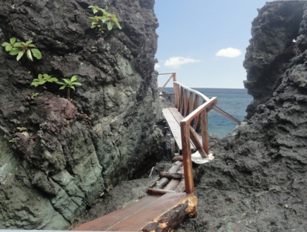
 Long Island is a pioneer station with a remarkable history of forestry. Located just 42 nautical miles from Port Blair.
Long Island is a dreamland settlement without any road network. Only four feet wide concrete footpath connects different
parts of the 'panchayat' area starting from the jetty.
Long Island is a pioneer station with a remarkable history of forestry. Located just 42 nautical miles from Port Blair.
Long Island is a dreamland settlement without any road network. Only four feet wide concrete footpath connects different
parts of the 'panchayat' area starting from the jetty.
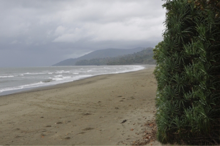
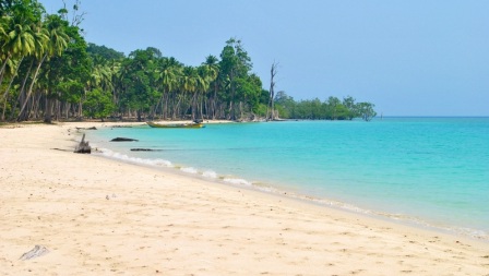 Lalaji Bay beach is a beautiful, sandy beach on the west coast of Long Island.
Fringing north eastern edge of Long Island, this beautiful beach is approachable from Long Island
settlement by trekking.
Lalaji Bay beach is a beautiful, sandy beach on the west coast of Long Island.
Fringing north eastern edge of Long Island, this beautiful beach is approachable from Long Island
settlement by trekking.
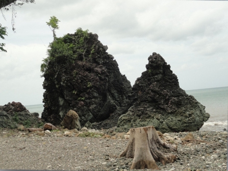
 A lovely island near Long Island. Guitar Shaped, this island is one of the most beautiful island.
Guitar Island is an uninhabited Island and no accommodation facility is available.
Tourists need to halt either at Long Island or Rangat
A lovely island near Long Island. Guitar Shaped, this island is one of the most beautiful island.
Guitar Island is an uninhabited Island and no accommodation facility is available.
Tourists need to halt either at Long Island or Rangat
 Merk Bay Beach in North Passage island comes under the area of Middle Andaman.
On the way to the island, one can see Strait island on the right and Guitar island on the left.
Merk Bay Beach in North Passage island comes under the area of Middle Andaman.
On the way to the island, one can see Strait island on the right and Guitar island on the left.
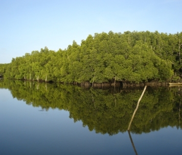 Yeratta, which is well connected by road has breathtaking scenic beauty of various species of
mangroves and is an ideal location to learn about mangroves.
Yeratta, which is well connected by road has breathtaking scenic beauty of various species of
mangroves and is an ideal location to learn about mangroves.
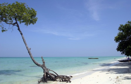
 One of the most beautiful beaches of Middle Andaman Island having a very good sandy beach.A long beach
having a stretch of 5-6 Kilometers along the Bay.
One of the most beautiful beaches of Middle Andaman Island having a very good sandy beach.A long beach
having a stretch of 5-6 Kilometers along the Bay.
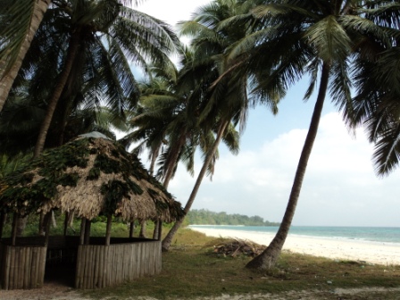
 This sea Beach is the main outing area and recreation for the people of Rangat and adjoining villages.
The beach has been divided into various sections viz. Eco-huts, Casurina Grove, Jamuna Grove, Pandanus Grove.
This sea Beach is the main outing area and recreation for the people of Rangat and adjoining villages.
The beach has been divided into various sections viz. Eco-huts, Casurina Grove, Jamuna Grove, Pandanus Grove.
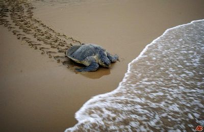 Cuthbert Bay Beach is located at a distance of 12 km. from Rangat.
This is a lengthy beach with a tropical forest bordering the beach. Apart from the beach,
which is famous for turtle nesting in season, the tropical forest offers elephant safaris.
Tourist can also visit the elephant training camps
Cuthbert Bay Beach is located at a distance of 12 km. from Rangat.
This is a lengthy beach with a tropical forest bordering the beach. Apart from the beach,
which is famous for turtle nesting in season, the tropical forest offers elephant safaris.
Tourist can also visit the elephant training camps
 Panchavathi Hills Have a very Beautiful gentle waterfall.The agricultural form en-route housing a rich bank of
vegetation is of interest to botany enthusiasts.
Panchavathi Hills Have a very Beautiful gentle waterfall.The agricultural form en-route housing a rich bank of
vegetation is of interest to botany enthusiasts.
 Barren Island is the only confirmed active volcano in South Asia.
The waters surrounding Barren Island are reputed to be among the world's top scuba diving destinations.
Major attractions here are the crystal clear visibility, Manta Rays, interesting basalt formations,
topography of past lava flows and fast growing coral gardens.
Barren Island is the only confirmed active volcano in South Asia.
The waters surrounding Barren Island are reputed to be among the world's top scuba diving destinations.
Major attractions here are the crystal clear visibility, Manta Rays, interesting basalt formations,
topography of past lava flows and fast growing coral gardens.
 Moricedera is an ideal location for picnic in an natural environment of sea on one side and lush green forest on the
other side. The site has been developed and furnished in an eco-friendly manner.
Long Island is a pioneer station with a remarkable history of forestry. Located just 42 nautical miles from Port Blair.
Long Island is a dreamland settlement without any road network. Only four feet wide concrete footpath connects different
parts of the 'panchayat' area starting from the jetty.
Lalaji Bay beach is a beautiful, sandy beach on the west coast of Long Island.
Fringing north eastern edge of Long Island, this beautiful beach is approachable from Long Island
settlement by trekking.
A lovely island near Long Island. Guitar Shaped, this island is one of the most beautiful island.
Guitar Island is an uninhabited Island and no accommodation facility is available.
Tourists need to halt either at Long Island or Rangat.
Merk Bay Beach in North Passage island comes under the area of Middle Andaman.
On the way to the island, one can see Strait island on the right and Guitar island on the left.
Yeratta, which is well connected by road has breathtaking
scenic beauty of various species of mangroves and is an ideal location to learn about mangroves. Moreover,
as a step towards creating awareness among general public about mangroves, eco-tourism etc.
Moricedera is an ideal location for picnic in an natural environment of sea on one side and lush green forest on the
other side. The site has been developed and furnished in an eco-friendly manner.
Long Island is a pioneer station with a remarkable history of forestry. Located just 42 nautical miles from Port Blair.
Long Island is a dreamland settlement without any road network. Only four feet wide concrete footpath connects different
parts of the 'panchayat' area starting from the jetty.
Lalaji Bay beach is a beautiful, sandy beach on the west coast of Long Island.
Fringing north eastern edge of Long Island, this beautiful beach is approachable from Long Island
settlement by trekking.
A lovely island near Long Island. Guitar Shaped, this island is one of the most beautiful island.
Guitar Island is an uninhabited Island and no accommodation facility is available.
Tourists need to halt either at Long Island or Rangat.
Merk Bay Beach in North Passage island comes under the area of Middle Andaman.
On the way to the island, one can see Strait island on the right and Guitar island on the left.
Yeratta, which is well connected by road has breathtaking
scenic beauty of various species of mangroves and is an ideal location to learn about mangroves. Moreover,
as a step towards creating awareness among general public about mangroves, eco-tourism etc. As a step towards creating awareness among general public about mangroves, the Department of Environment & Forest
has established a Mangrove Interpretation Centre(MIC) at Yeratta.
It has attractive display panels depicting various species of mangroves found in these Islands.
As a step towards creating awareness among general public about mangroves, the Department of Environment & Forest
has established a Mangrove Interpretation Centre(MIC) at Yeratta.
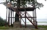
It has attractive display panels depicting various species of mangroves found in these Islands.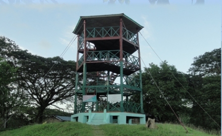 Mangrove View Watch Tower is an unique structure of its kind which provides an opportunity to have a
panoramic view of mangroves & adjacent forests. This is the only such Tower in whole of A&N islands
to view mangroves.The height of the Watch Tower is 13 mtrs.
Mangrove View Watch Tower is an unique structure of its kind which provides an opportunity to have a
panoramic view of mangroves & adjacent forests. This is the only such Tower in whole of A&N islands
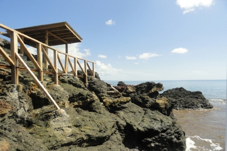
to view mangroves.The height of the Watch Tower is 13 mtrs.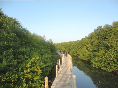 The Department of Environment & Forests has developed a Mangrove trail having 300 mtrs, stretch of bench walk
passing through the natural Mangrove forest which is an important tourist attraction here. The benchwalk gives the
visitors a fantastic feel of mangroves.
Daninallah Beach is one of the most beautiful beaches of Middle Andaman Island having a very good sandy beach.
The Department of Environment & Forests has developed a Mangrove trail having 300 mtrs, stretch of bench walk
passing through the natural Mangrove forest which is an important tourist attraction here. The benchwalk gives the
visitors a fantastic feel of mangroves.
Daninallah Beach is one of the most beautiful beaches of Middle Andaman Island having a very good sandy beach.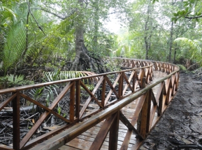 it is a wooden board-walk meandering through a creek for a distance of 713 mtrs.
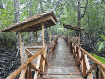 It is longest walkway of its kind in the country
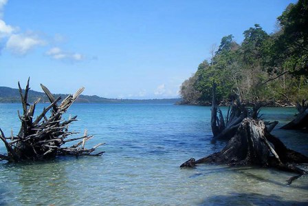 Aamkunj Sea Beach is located at a distance of about 08 kms from Rangat towards Mayabander and about a km from the
Nimbutala helipad.
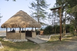
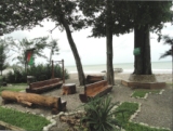
The Eco-Huts as the name suggests are made using eco-friendly materials that are available in the forest.
Aamkunj Sea Beach is located at a distance of about 08 kms from Rangat towards Mayabander and about a km from the
Nimbutala helipad.
The Eco-Huts as the name suggests are made using eco-friendly materials that are available in the forest.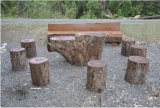 The Groves are named after the naturally available flora at the locality viz:
 The Sanctuary comprises about 8 kms of sandy beach at the coast of the Middle Andaman Islands and continues
for about 600 mts inside the land from the high tide mark along the coast.
The Sanctuary comprises about 8 kms of sandy beach at the coast of the Middle Andaman Islands and continues
for about 600 mts inside the land from the high tide mark along the coast.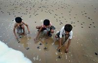 The sanctuary is known as one of the most important turtle nesting beaches in Andaman and Nicobar Islands.
The Turtles come to the beach only to lay eggs They dig a pit,lay eggs and go back to the sea.
This event takes during the night. In the Sanctuary the turtles come on the beach almost every single
night during the season.
The sanctuary is known as one of the most important turtle nesting beaches in Andaman and Nicobar Islands.
The Turtles come to the beach only to lay eggs They dig a pit,lay eggs and go back to the sea.
This event takes during the night. In the Sanctuary the turtles come on the beach almost every single
night during the season.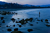 It is mostly visited by Olive Ridley turtle.Green sea turtles often visit this beach and Hawksbill
and Leatherback turtles have also been reported to visit occasionally.
Turtle nesting takes place from Nov-March every year.
Panchavathi Hills Have a very Beautiful gentle waterfall.The agricultural form en-route housing a rich bank of
vegetation is of interest to botany enthusiasts.
It is mostly visited by Olive Ridley turtle.Green sea turtles often visit this beach and Hawksbill
and Leatherback turtles have also been reported to visit occasionally.
Turtle nesting takes place from Nov-March every year.
Panchavathi Hills Have a very Beautiful gentle waterfall.The agricultural form en-route housing a rich bank of
vegetation is of interest to botany enthusiasts. The waterfall was surf-white. It was drizzling onto the rocks. At its widest point, it was surging
and plunging down the mountain. It had a beautiful serenity-pool at the bottom. It was veneer clear.
The waterfall flowed as smoothly as syrup. The frogs croaking nearby added to the wonderful sounds.
The flowers growing nearby had a honey sweet smell.
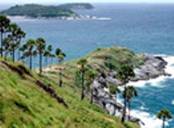
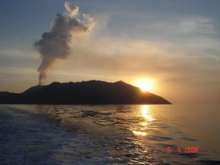
Barren Islands is located in the Andaman Sea and is one of the most easterly of the Andaman Islands.
Barren Islands is the only confirmed active volcano in South Asia.
The waterfall was surf-white. It was drizzling onto the rocks. At its widest point, it was surging
and plunging down the mountain. It had a beautiful serenity-pool at the bottom. It was veneer clear.
The waterfall flowed as smoothly as syrup. The frogs croaking nearby added to the wonderful sounds.
The flowers growing nearby had a honey sweet smell.
Barren Islands is located in the Andaman Sea and is one of the most easterly of the Andaman Islands.
Barren Islands is the only confirmed active volcano in South Asia.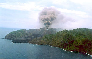 The first recorded eruptions of the volcano on Barren Islands date back
to 1787. Since then, the volcano has erupted more than six times and the most recent eruption was on 2 May 2006.
The first recorded eruptions of the volcano on Barren Islands date back
to 1787. Since then, the volcano has erupted more than six times and the most recent eruption was on 2 May 2006.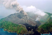 Smoke rises from the Barren Island volcano Justifying its name, Barren Islands is a barren area
uninhabited by humans, though with a small population of goats. Also birds, bats like flying foxes and a few
rodent species such as rats are known to survive the harsh conditions of the region. An eruption began on 28th
May 2005.
Smoke rises from the Barren Island volcano Justifying its name, Barren Islands is a barren area
uninhabited by humans, though with a small population of goats. Also birds, bats like flying foxes and a few
rodent species such as rats are known to survive the harsh conditions of the region. An eruption began on 28th
May 2005. Moricedera is an ideal location for picnic in an natural environment of sea on one side and lush green forest on the
other side.
Moricedera is an ideal location for picnic in an natural environment of sea on one side and lush green forest on the
other side. 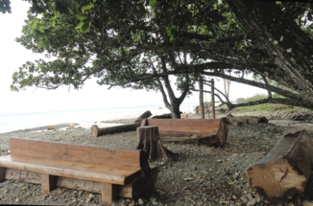 As the name suggests, there is a profused dense growth of Poon trees (Calophyllum inophyllum) which makes this location
ideal for enjoyment
As the name suggests, there is a profused dense growth of Poon trees (Calophyllum inophyllum) which makes this location
ideal for enjoyment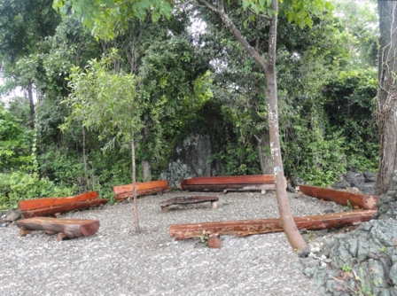 The Grove is named after sea Mohwa tree locally known as 'Andaman Bulletwood Tree' (Manilkara littoralis).
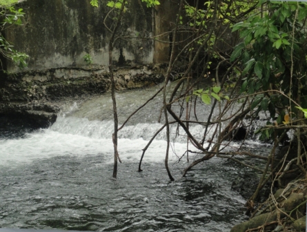 A fresh water stream located at this site is not only perennial but also scenic. It acts as natural swimming pool for
visitors
A fresh water stream located at this site is not only perennial but also scenic. It acts as natural swimming pool for
visitors